
Mount San Jacinto State Park topographic map
Interactive map
Click on the map to display elevation.
About this map
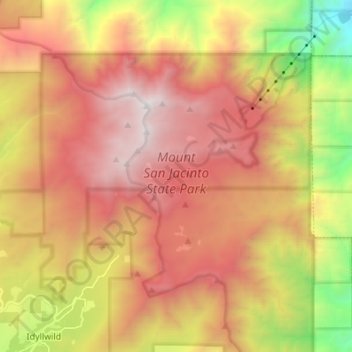
Name: Mount San Jacinto State Park topographic map, elevation, terrain.
Average elevation: 6,788 ft
Minimum elevation: 1,923 ft
Maximum elevation: 10,764 ft
Other topographic maps
Click on a map to view its topography, its elevation and its terrain.
Pine Cove
United States > California > Riverside County > Idyllwild-Pine Cove
Pine Cove, Idyllwild-Pine Cove, Riverside County, California, 92549, United States
Average elevation: 5,876 ft