
Burgess Hill topographic map
Interactive map
Click on the map to display elevation.
About this map
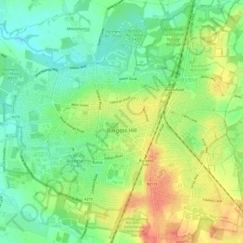
Name: Burgess Hill topographic map, elevation, terrain.
Location: Burgess Hill, Mid Sussex, West Sussex, England, United Kingdom (50.94034 -0.15936 50.97726 -0.10422)
Average elevation: 131 ft
Minimum elevation: 52 ft
Maximum elevation: 230 ft
Other topographic maps
Click on a map to view its topography, its elevation and its terrain.
Bolney
United Kingdom > England > West Sussex > Mid Sussex
Bolney, Mid Sussex, West Sussex, England, United Kingdom
Average elevation: 171 ft