
Wachenheim an der Weinstraße topographic map
Interactive map
Click on the map to display elevation.
About this map
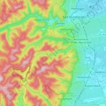
Name: Wachenheim an der Weinstraße topographic map, elevation, terrain.
Average elevation: 663 ft
Minimum elevation: 331 ft
Maximum elevation: 1,785 ft
Other topographic maps
Click on a map to view its topography, its elevation and its terrain.
Bad Dürkheim
Germany > Rhineland-Palatinate > Landkreis Bad Dürkheim
Bad Dürkheim, Landkreis Bad Dürkheim, Rhineland-Palatinate, 67098, Germany
Average elevation: 709 ft