
Blackwell Peninsula topographic map
Interactive map
Click on the map to display elevation.
About this map
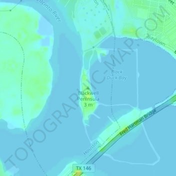
Name: Blackwell Peninsula topographic map, elevation, terrain.
Average elevation: 7 ft
Minimum elevation: -26 ft
Maximum elevation: 66 ft
Other topographic maps
Click on a map to view its topography, its elevation and its terrain.
Black Cat Ridge
United States > Texas > Harris County > Houston
Black Cat Ridge, Houston, Harris County, Texas, 77339, United States
Average elevation: 79 ft
Tuffly Park
United States > Texas > Harris County > Houston
Tuffly Park, 3200, Greater Fifth Ward, Houston, Harris County, Texas, 77026, United States
Average elevation: 52 ft
Kings Point
United States > Texas > Harris County > Houston
Kings Point, Houston, Harris County, Texas, 77345, United States
Average elevation: 66 ft
Kingwood
United States > Texas > Harris County > Houston
Kingwood, Houston, Harris County, Texas, 77345, United States
Average elevation: 72 ft
Forest Cove
United States > Texas > Harris County > Houston
Forest Cove, Houston, Harris County, Texas, 77339, United States
Average elevation: 79 ft
East Houston
United States > Texas > Harris County > Houston > East Houston
East Houston, Houston, Harris County, Texas, 77028, United States
Average elevation: 49 ft
Harrisburg
United States > Texas > Harris County > Houston > Harrisburg
Harrisburg, Houston, Harris County, Texas, 77012, United States
Average elevation: 33 ft
Alief
United States > Texas > Harris County > Houston
Alief, Houston, Harris County, Texas, 77099, United States
Average elevation: 82 ft
Addicks
United States > Texas > Harris County > Houston > Addicks
Addicks, Houston, Harris County, Texas, 77077, United States
Average elevation: 92 ft