
Humcha topographic map
Interactive map
Click on the map to display elevation.
About this map
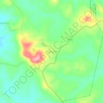
Name: Humcha topographic map, elevation, terrain.
Location: Humcha, Hosanagara taluk, Shimoga district, Karnataka, India (13.84236 75.18732 13.88236 75.22732)
Average elevation: 2,287 ft
Minimum elevation: 2,126 ft
Maximum elevation: 2,589 ft
Other topographic maps
Click on a map to view its topography, its elevation and its terrain.
Nagodi
India > Karnataka > Hosanagara taluk
Nagodi, Hosanagara taluk, Shimoga District, Karnataka, India
Average elevation: 2,149 ft