
Make a donation
Gear up for your next adventure:
As an Amazon Associate, this site earns from qualifying purchases at no extra cost to you.
Pankow topographic map
Click on the map to display elevation.
Make a donation
Gear up for your next adventure:
As an Amazon Associate, this site earns from qualifying purchases at no extra cost to you.
About this map
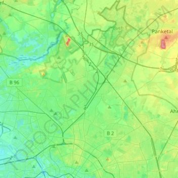
Name: Pankow topographic map, elevation, terrain.
Location: Pankow, Berlin, Germany (52.51993 13.34756 52.67551 13.52302)
Average elevation: 174 ft
Minimum elevation: 95 ft
Maximum elevation: 377 ft
Make a donation
Gear up for your next adventure:
As an Amazon Associate, this site earns from qualifying purchases at no extra cost to you.
Other topographic maps
Click on a map to view its topography, its elevation and its terrain.
Teufelsberg
Teufelsberg was originally thought to be 115 metres (377 ft) high, which placed it at the same elevation as Großer Müggelberg (the summit of Müggelberge), and was the highest point in West Berlin. New measurements show that Teufelsberg is actually 120.1 metres (394 ft) high, making it higher than Großer…
Average elevation: 177 ft
Viktoriapark
On the occasion of the elevation of the monument ideas appeared to lay out a park around it. Two years later the design of a park was put out to tender. Hermann Mächtig (*1837-1909*), since 1877 Berlin's city garden director, handed in a design, already using the name Victoria Park, in honour of Princess…
Average elevation: 148 ft
Make a donation
Gear up for your next adventure:
As an Amazon Associate, this site earns from qualifying purchases at no extra cost to you.