
Hay on Wye topographic map
Interactive map
Click on the map to display elevation.
About this map
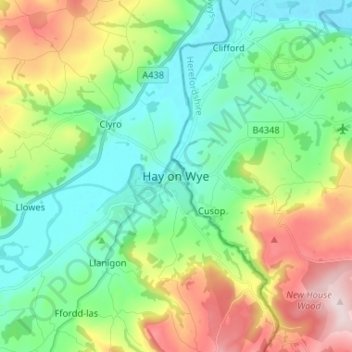
Name: Hay on Wye topographic map, elevation, terrain.
Location: Hay on Wye, Powys, Wales, HR3 5AG, United Kingdom (52.03446 -3.16431 52.11446 -3.08431)
Average elevation: 653 ft
Minimum elevation: 210 ft
Maximum elevation: 1,601 ft
Other topographic maps
Click on a map to view its topography, its elevation and its terrain.
Llanwrtyd Wells
United Kingdom > Wales > Powys
Llanwrtyd Wells, Powys, Wales, LD5 4ST, United Kingdom
Average elevation: 971 ft
Llan
United Kingdom > Wales > Powys
Llan, Powys, Wales, SY19 7DW, United Kingdom
Average elevation: 761 ft
Newtown
United Kingdom > Wales > Powys
Newtown, Powys, Wales, SY16 1AQ, United Kingdom
Average elevation: 679 ft