
Barossa Valley District topographic map
Interactive map
Click on the map to display elevation.
About this map
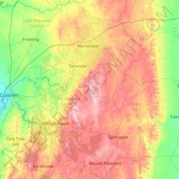
Name: Barossa Valley District topographic map, elevation, terrain.
Average elevation: 965 ft
Minimum elevation: 148 ft
Maximum elevation: 2,057 ft
Other topographic maps
Click on a map to view its topography, its elevation and its terrain.
Brenda Park
Australia > South Australia > Mid Murray Council
Brenda Park, Mid Murray Council, South Australia, 5320, Australia
Average elevation: 75 ft
Dutton
Australia > South Australia > Mid Murray Council
Dutton, Mid Murray Council, South Australia, 5356, Australia
Average elevation: 1,201 ft
Blanchetown
Australia > South Australia > Mid Murray Council
Blanchetown, Mid Murray Council, South Australia, 5357, Australia
Average elevation: 171 ft
Sedan
Australia > South Australia > Mid Murray Council > Sedan
Sedan, Mid Murray Council, South Australia, 5353, Australia
Average elevation: 531 ft