
Thank you for supporting this site ❤️
Make a donation
Make a donation
Gear up for your next adventure:
As an Amazon Associate, this site earns from qualifying purchases at no extra cost to you.
Zizur Mayor/Zizur Nagusia topographic map
Click on the map to display elevation.
Thank you for supporting this site ❤️
Make a donation
Make a donation
Gear up for your next adventure:
As an Amazon Associate, this site earns from qualifying purchases at no extra cost to you.
About this map
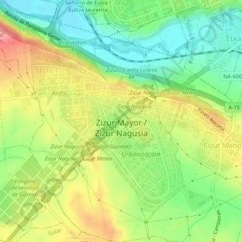
Name: Zizur Mayor/Zizur Nagusia topographic map, elevation, terrain.
Average elevation: 1,460 ft
Minimum elevation: 1,302 ft
Maximum elevation: 1,657 ft
Thank you for supporting this site ❤️
Make a donation
Make a donation
Gear up for your next adventure:
As an Amazon Associate, this site earns from qualifying purchases at no extra cost to you.
Other topographic maps
Click on a map to view its topography, its elevation and its terrain.
Zulueta
Spain > Navarre > Iruñerria / Comarca de Pamplona > Valle de Elorz / Elortzibar
Average elevation: 1,713 ft