Geolocate

Yangcheon-gu topographic map

Click on the map to display elevation.

About this map

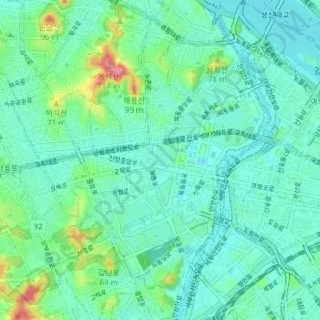
Name: Yangcheon-gu topographic map, elevation, terrain.

Location: Yangcheon-gu, Seoul, South Korea (37.50287 126.82159 37.55124 126.89068)

Average elevation: 75 ft

Minimum elevation: -7 ft

Maximum elevation: 367 ft

Other topographic maps

Click on a map to view its topography, its elevation and its terrain.

Cheonggyecheon (Stream)

South Korea > Seoul

Average elevation: 98 ft

Jamsil Hanriver park

South Korea > Seoul

Average elevation: 56 ft

Cheonggyecheon (Stream)

South Korea > Seoul

Average elevation: 105 ft

달터마을

South Korea > Seoul

Average elevation: 177 ft

Haebangchon

South Korea > Seoul

Average elevation: 243 ft

Cheonggyecheon (Stream)

South Korea > Seoul

Average elevation: 98 ft

Ansan Mountain

South Korea > Seoul

Average elevation: 325 ft

Gear up for your next adventure:

🔦Powerful Headlamps - Ultra-bright hands-free lighting for night navigation
🥾Men's Hiking Boots - Durable, waterproof footwear for rugged terrain and steep inclines
🧼Biodegradable Camping Soap - Eco‑friendly soap for outdoor hygiene
🔦LED Headlamp - Bright and durable LED headlamp for night navigation
❄️Traction Cleats - Prevent slips on icy trails during winter hikes

As an Amazon Associate, this site earns from qualifying purchases at no extra cost to you.