
Labyar topographic map
Interactive map
Click on the map to display elevation.
About this map
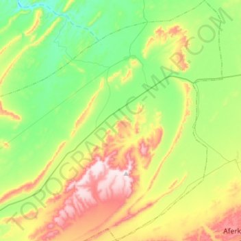
Name: Labyar topographic map, elevation, terrain.
Average elevation: 804 ft
Minimum elevation: 180 ft
Maximum elevation: 1,919 ft
Other topographic maps
Click on a map to view its topography, its elevation and its terrain.
Fayja
Maroc > Cercle de Laqsabi > Echatea El Abied
Fayja, Echatea El Abied, caïdat d'Echatea El Abied, Cercle de Laqsabi, Province de Guelmim, Guelmim-Oued Noun, Maroc
Average elevation: 423 ft
Rass Oumlil
Rass Oumlil, Caïdat de Labyar, Cercle de Laqsabi, Province de Guelmim, Guelmim-Oued Noun, Maroc
Average elevation: 486 ft
Targa Wassay
Targa Wassay, Caïdat de Laqsabi, Cercle de Laqsabi, Province de Guelmim, Guelmim-Oued Noun, Maroc
Average elevation: 771 ft
Laqsabi Tagoust
Laqsabi Tagoust, Caïdat de Laqsabi, Cercle de Laqsabi, Province de Guelmim, Guelmim-Oued Noun, Maroc
Average elevation: 833 ft