
Guimarães topographic map
Interactive map
Click on the map to display elevation.
About this map
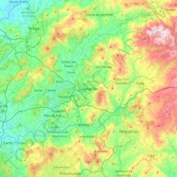
Name: Guimarães topographic map, elevation, terrain.
Location: Guimarães, Braga, Ave, Norte, 4810-442, Portugal (41.40177 -8.33557 41.48177 -8.25557)
Average elevation: 843 ft
Minimum elevation: 322 ft
Maximum elevation: 1,972 ft
Other topographic maps
Click on a map to view its topography, its elevation and its terrain.
Eira Velha
Portugal > Norte > Guimarães > Briteiros (Santa Leocádia) > Eira Velha
Eira Velha, Briteiros (Santa Leocádia), Briteiros (São Salvador) e Briteiros (Santa Leocádia), Guimarães, Braga, Norte, 4805-015, Portugal
Average elevation: 787 ft