Geolocate

Hudson topographic map

Click on the map to display elevation.

About this map

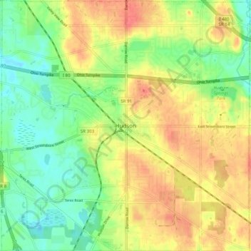
Name: Hudson topographic map, elevation, terrain.

Location: Hudson, Summit County, Ohio, United States (41.20285 -81.48964 41.27705 -81.39183)

Average elevation: 1,063 ft

Minimum elevation: 971 ft

Maximum elevation: 1,161 ft

Summit County trails, hiking, mountain biking, running and outdoor activities

Other topographic maps

Click on a map to view its topography, its elevation and its terrain.

Mud Brook Falls

United States > Ohio > Summit County > Cuyahoga Falls

Average elevation: 1,004 ft

Boston

United States > Ohio > Summit County

Average elevation: 804 ft

Greensburg

United States > Ohio > Summit County > Green

Average elevation: 1,175 ft

Metz

United States > Ohio > Summit County > Stow

Average elevation: 1,043 ft

Little Cuyahoga River

United States > Ohio > Summit County > Akron

Average elevation: 948 ft

Copley

United States > Ohio > Summit County

Average elevation: 1,043 ft

Sagamore Hills

United States > Ohio > Summit County

Average elevation: 866 ft

Maple Grove Park

United States > Ohio > Summit County > Hudson

Average elevation: 1,037 ft

Decker Park

United States > Ohio > Summit County > Barberton

Average elevation: 997 ft

Myersville

United States > Ohio > Summit County > Green

Average elevation: 1,122 ft

Metz

United States > Ohio > Summit County > Stow

Average elevation: 1,043 ft

Gear up for your next adventure:

GPS Sports Watch - GPS watch for running, hiking and training
💧Water Purification System - Clean water on the trail with reliable purifiers
🧭Outdoor Navigation Book - Learn advanced navigation skills
🎒Hydration Pack - Hands‑free water reservoir for long hikes
🛏️Cold Weather Sleeping Bag - Warm sleeping bag for cold conditions

As an Amazon Associate, this site earns from qualifying purchases at no extra cost to you.