
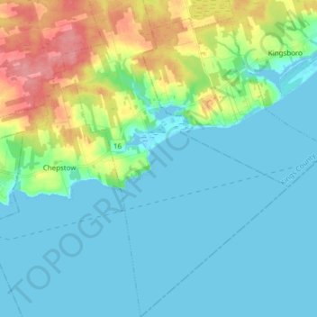
Lot 46 topographic map
Interactive map
Click on the map to display elevation.
About this map
Name: Lot 46 topographic map, elevation, terrain.
Average elevation: 62 ft
Minimum elevation: -10 ft
Maximum elevation: 256 ft
Other topographic maps
Click on a map to view its topography, its elevation and its terrain.
Lot 53
Canada > Île-du-Prince-Édouard > Kings County > Glenfanning
Lot 53, Glenfanning, Town of Three Rivers, Kings County, Île-du-Prince-Édouard, C0A 1G0, Canada
Average elevation: 92 ft
Valleyfield
Canada > Île-du-Prince-Édouard > Kings County > Valleyfield
Valleyfield, Town of Three Rivers, Kings County, Île-du-Prince-Édouard, Canada
Average elevation: 128 ft
Saint Andrews
Canada > Île-du-Prince-Édouard > Kings County > Saint Andrews
Saint Andrews, Kings County, Île-du-Prince-Édouard, Canada
Average elevation: 39 ft
St. Peters Bay
Canada > Île-du-Prince-Édouard > Kings County > St. Peters Bay
St. Peters Bay, Rural Municipality of St. Peters, Kings County, Île-du-Prince-Édouard, C0A 2A0, Canada
Average elevation: 75 ft