
Heliopolis topographic map
Interactive map
Click on the map to display elevation.
About this map
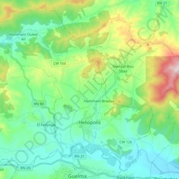
Name: Heliopolis topographic map, elevation, terrain.
Location: Heliopolis, Daïra Heliopolis, Guelma, 24008, Algérie (36.46900 7.33312 36.59224 7.50172)
Average elevation: 1,142 ft
Minimum elevation: 522 ft
Maximum elevation: 2,789 ft
Other topographic maps
Click on a map to view its topography, its elevation and its terrain.
El Fedjoudj
Algérie > Guelma > Daïra Heliopolis > El Fedjoudj
El Fedjoudj, Daïra Heliopolis, Guelma, 24019, Algérie
Average elevation: 1,063 ft