
Fuentes de Ebro topographic map
Interactive map
Click on the map to display elevation.
About this map
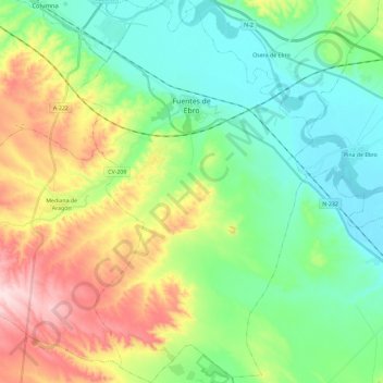
Name: Fuentes de Ebro topographic map, elevation, terrain.
Location: Fuentes de Ebro, Zaragoza, Saragosse, Aragon, 50740, Espagne (41.38550 -0.69890 41.55915 -0.55474)
Average elevation: 843 ft
Minimum elevation: 509 ft
Maximum elevation: 1,542 ft
Other topographic maps
Click on a map to view its topography, its elevation and its terrain.