Geolocate

Maribor topographic map

Click on the map to display elevation.

About this map

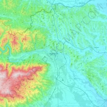
Name: Maribor topographic map, elevation, terrain.

Location: Maribor, 2000, Slovenia (46.39764 15.48559 46.71764 15.80559)

Average elevation: 1,375 ft

Minimum elevation: 705 ft

Maximum elevation: 4,400 ft

Gear up for your next adventure:

🦺Reflective Outdoor Gear - Safety gear for low‑light conditions
🪶Compact Camp Shovel - Folding shovel for campsite tasks
🪶Camp Gear Gift Set - Perfect gift bundle for outdoor fans
☀️Outdoor Sunscreen - High protection sunscreen for outdoor activities
🖼️Topo Map Wall Art - Decorative topographic prints of famous peaks and regions

As an Amazon Associate, this site earns from qualifying purchases at no extra cost to you.