
Make a donation
Gear up for your next adventure:
As an Amazon Associate, this site earns from qualifying purchases at no extra cost to you.
Gajwel topographic map
Click on the map to display elevation.
Make a donation
Gear up for your next adventure:
As an Amazon Associate, this site earns from qualifying purchases at no extra cost to you.
Gajwel
The town is located on the Deccan Plateau and is surrounded by agricultural lands. It lies at an average elevation of around 540 meters (1,770 feet) above sea level. The area is characterized by undulating terrain with scattered hills and valleys.
Make a donation
Gear up for your next adventure:
As an Amazon Associate, this site earns from qualifying purchases at no extra cost to you.
About this map
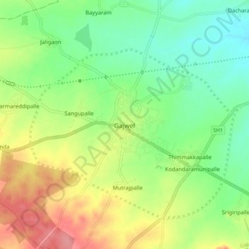
Name: Gajwel topographic map, elevation, terrain.
Average elevation: 1,864 ft
Minimum elevation: 1,745 ft
Maximum elevation: 2,034 ft
Make a donation
Gear up for your next adventure:
As an Amazon Associate, this site earns from qualifying purchases at no extra cost to you.