
Thank you for supporting this site ❤️
Make a donation
Make a donation
Gear up for your next adventure:
As an Amazon Associate, this site earns from qualifying purchases at no extra cost to you.
Andler topographic map
Click on the map to display elevation.
Thank you for supporting this site ❤️
Make a donation
Make a donation
Gear up for your next adventure:
As an Amazon Associate, this site earns from qualifying purchases at no extra cost to you.
About this map
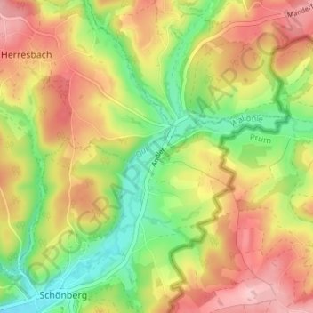
Name: Andler topographic map, elevation, terrain.
Location: Andler, Saint Vith, Verviers, Liège, Wallonia, 4780, Belgium (50.28643 6.26305 50.32643 6.30305)
Average elevation: 1,631 ft
Minimum elevation: 1,365 ft
Maximum elevation: 1,893 ft
Thank you for supporting this site ❤️
Make a donation
Make a donation
Gear up for your next adventure:
As an Amazon Associate, this site earns from qualifying purchases at no extra cost to you.