Geolocate

Staindrop topographic map

Click on the map to display elevation.

About this map

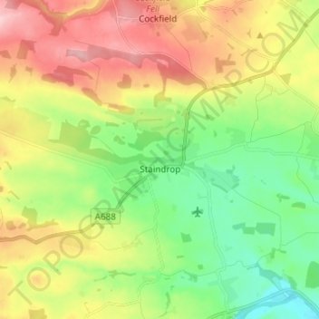
Name: Staindrop topographic map, elevation, terrain.

Location: Staindrop, County Durham, North East, England, United Kingdom (54.57066 -1.88372 54.59349 -1.76120)

Average elevation: 499 ft

Minimum elevation: 230 ft

Maximum elevation: 879 ft

Other topographic maps

Click on a map to view its topography, its elevation and its terrain.

Hamsterley

United Kingdom > England > County Durham

Average elevation: 433 ft

Toft Hill

United Kingdom > England > County Durham

Average elevation: 525 ft

Carrville

United Kingdom > England > County Durham

Average elevation: 246 ft

New Brancepeth

United Kingdom > England > County Durham

Average elevation: 463 ft

Gear up for your next adventure:

🧢Outdoor Hiking Hat - Sun protection hat for outdoor explorers
🚗GPS Dash Cams - Record your scenic drives through mountain passes and canyons
🦶Hiking Gaiters - Keep debris and water out of your boots
🪶Thermal Camp Blanket - Extra warmth for cold nights
🩳Quick‑Dry Hiking Shorts - Comfortable and quick‑dry shorts for summer hiking

As an Amazon Associate, this site earns from qualifying purchases at no extra cost to you.