
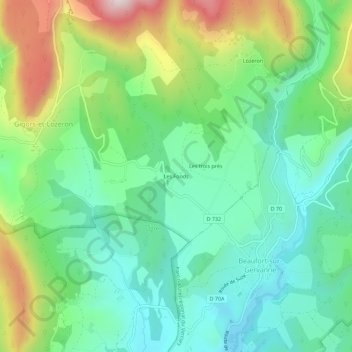
Les Fonds topographic map
Interactive map
Click on the map to display elevation.
About this map
Name: Les Fonds topographic map, elevation, terrain.
Average elevation: 1,591 ft
Minimum elevation: 1,010 ft
Maximum elevation: 2,838 ft
Other topographic maps
Click on a map to view its topography, its elevation and its terrain.
Lozeron
France > Auvergne-Rhône-Alpes > Drôme > Gigors-et-Lozeron > Lozeron
Lozeron, Gigors-et-Lozeron, Die, Drôme, Auvergne-Rhône-Alpes, France métropolitaine, 26400, France
Average elevation: 1,916 ft
Les Bérangers
France > Auvergne-Rhône-Alpes > Drôme > Gigors-et-Lozeron
Les Bérangers, Gigors-et-Lozeron, Die, Drôme, Auvergne-Rhône-Alpes, France métropolitaine, 26400, France
Average elevation: 1,867 ft