
Saint Pierre and Miquelon topographic map
Interactive map
Click on the map to display elevation.
About this map
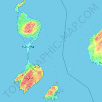
Name: Saint Pierre and Miquelon topographic map, elevation, terrain.
Location: Saint Pierre and Miquelon, France (46.74946 -56.51613 47.14426 -56.11896)
Average elevation: 36 ft
Minimum elevation: -3 ft
Maximum elevation: 755 ft
Other topographic maps
Click on a map to view its topography, its elevation and its terrain.
Saint-Pierre
France > Saint Pierre and Miquelon > Saint-Pierre
Saint-Pierre, Saint Pierre and Miquelon, 97500, France
Average elevation: 66 ft