
Matheron topographic map
Interactive map
Click on the map to display elevation.
About this map
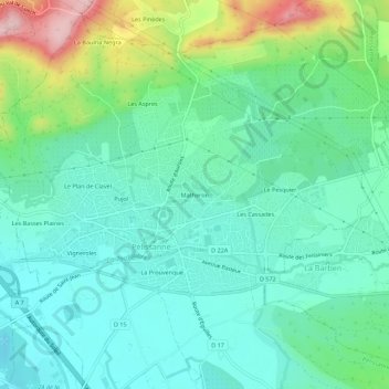
Name: Matheron topographic map, elevation, terrain.
Average elevation: 390 ft
Minimum elevation: 187 ft
Maximum elevation: 974 ft
Other topographic maps
Click on a map to view its topography, its elevation and its terrain.
Les Cassades
France > Provence-Alpes-Côte d'Azur > Bouches-du-Rhône > Pélissanne
Les Cassades, Pélissanne, Aix-en-Provence, Bouches-du-Rhône, Provence-Alpes-Côte d'Azur, France métropolitaine, 13330, France
Average elevation: 374 ft
Les Aspres
France > Provence-Alpes-Côte d'Azur > Bouches-du-Rhône > Pélissanne
Les Aspres, Pélissanne, Aix-en-Provence, Bouches-du-Rhône, Provence-Alpes-Côte d'Azur, France métropolitaine, 13330, France
Average elevation: 512 ft
Pujol
France > Provence-Alpes-Côte d'Azur > Bouches-du-Rhône > Pélissanne
Pujol, Pélissanne, Aix-en-Provence, Bouches-du-Rhône, Provence-Alpes-Côte d'Azur, France métropolitaine, 13330, France
Average elevation: 387 ft
La Prouvenque
France > Provence-Alpes-Côte d'Azur > Bouches-du-Rhône > Pélissanne
La Prouvenque, Pélissanne, Aix-en-Provence, Bouches-du-Rhône, Provence-Alpes-Côte d'Azur, France métropolitaine, 13330, France
Average elevation: 315 ft
Le Plan de Clavel
France > Provence-Alpes-Côte d'Azur > Bouches-du-Rhône > Pélissanne
Le Plan de Clavel, Pélissanne, Aix-en-Provence, Bouches-du-Rhône, Provence-Alpes-Côte d'Azur, France métropolitaine, 13330, France
Average elevation: 400 ft