
Kharadi topographic map
Interactive map
Click on the map to display elevation.
About this map
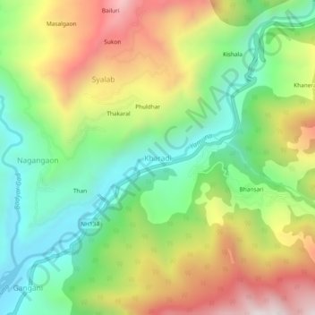
Name: Kharadi topographic map, elevation, terrain.
Average elevation: 5,341 ft
Minimum elevation: 4,058 ft
Maximum elevation: 7,149 ft
Other topographic maps
Click on a map to view its topography, its elevation and its terrain.
Barota
India > Uttarakhand > Rajgarhi
Barota, Rajgarhi, Uttarkashi district, Uttarakhand, 249141, India
Average elevation: 6,365 ft
Barkot
India > Uttarakhand > Rajgarhi > Barkot
Barkot, Rajgarhi, Uttarkashi district, Uttarakhand, India
Average elevation: 5,341 ft