
Parroquia Puerto Baquerizo Moreno topographic map
Interactive map
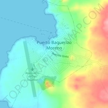
Click on the map to display elevation.
About this map
Name: Parroquia Puerto Baquerizo Moreno topographic map, elevation, terrain.
Average elevation: 115 ft
Minimum elevation: 0 ft
Maximum elevation: 367 ft
Puerto Baquerizo Moreno is the capital and administrative centre of Ecuador's Galápagos Province. It is located on the southwestern coast of San Cristóbal, and the town is also nicknamed Cristóbal by the local people, after the island. Its average elevation is 6 metres (20 ft). The central part of the town, including the road to El Progreso, has paved roads. The headquarters of the navy and the national police are located in the town. It has a post office, police station and hospital. A branch campus of Universidad San Francisco de Quito is situated in the town.
Other topographic maps
Click on a map to view its topography, its elevation and its terrain.
Isla Floreana
Ecuador > Galápagos > Cantón San Cristóbal
Isla Floreana, Cantón San Cristóbal, Galápagos, Ecuador
Average elevation: 299 ft
Isla Santa Fe
Ecuador > Galápagos > Cantón San Cristóbal
Isla Santa Fe, Parroquia Isla Santa María (Floreana) (Cab. en Pto. Velasco Ibarra), Cantón San Cristóbal, Galápagos, Ecuador
Average elevation: 174 ft
San Cristóbal
Ecuador > Galápagos > Cantón San Cristóbal > El Progreso
San Cristóbal, El Progreso, Parroquia El Progresso, Cantón San Cristóbal, Galápagos, Ecuador
Average elevation: 646 ft