
Rostizkogel topographic map
Interactive map
Click on the map to display elevation.
About this map
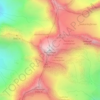
Name: Rostizkogel topographic map, elevation, terrain.
Location: Rostizkogel, St. Leonhard im Pitztal, Imst, Tirol, Österreich (46.96875 10.79543 46.96885 10.79553)
Average elevation: 9,633 ft
Minimum elevation: 7,953 ft
Maximum elevation: 11,033 ft
Other topographic maps
Click on a map to view its topography, its elevation and its terrain.
Waze
Österreich > Tirol > St. Leonhard im Pitztal
Waze, St. Leonhard im Pitztal, Imst, Tirol, Österreich
Average elevation: 9,619 ft
Verpeilspitze
Österreich > Tirol > St. Leonhard im Pitztal
Verpeilspitze, St. Leonhard im Pitztal, Imst, Tirol, Österreich
Average elevation: 9,344 ft
Mittelbergferner
Österreich > Tirol > St. Leonhard im Pitztal
Mittelbergferner, BIG3 Aussichtsplattform, St. Leonhard im Pitztal, Imst, Tirol, 6481, Österreich
Average elevation: 9,764 ft
Taschachferner
Österreich > Tirol > St. Leonhard im Pitztal
Taschachferner, Pitztaler Gletschersteig, St. Leonhard im Pitztal, Imst, Tirol, 6481, Österreich
Average elevation: 10,525 ft