
Bormali topographic map
Interactive map
Click on the map to display elevation.
About this map
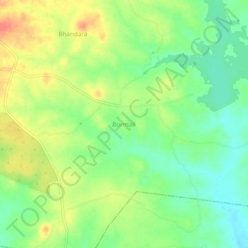
Name: Bormali topographic map, elevation, terrain.
Average elevation: 745 ft
Minimum elevation: 666 ft
Maximum elevation: 840 ft
Other topographic maps
Click on a map to view its topography, its elevation and its terrain.
Peeth
India > Rajasthan > Simalwara Tehsil
Peeth, Simalwara Tehsil, Dungarpur District, Rajasthan, 314406, India
Average elevation: 719 ft
Bhandara
India > Rajasthan > Simalwara Tehsil
Bhandara, Simalwara Tehsil, Dungarpur District, Rajasthan, India
Average elevation: 774 ft