
Charneca de Caparica topographic map
Interactive map
Click on the map to display elevation.
About this map
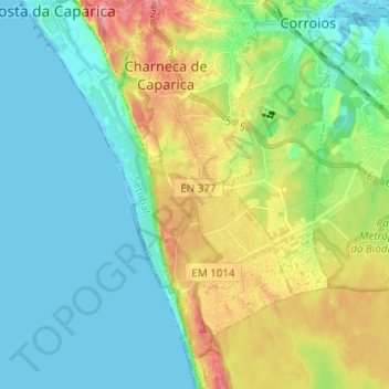
Name: Charneca de Caparica topographic map, elevation, terrain.
Location: Charneca de Caparica, Almada, Setúbal, Portugal (38.55053 -9.21243 38.64699 -9.15679)
Average elevation: 112 ft
Minimum elevation: -10 ft
Maximum elevation: 371 ft
Other topographic maps
Click on a map to view its topography, its elevation and its terrain.
Porto Brandão
Porto Brandão, Caparica e Trafaria, Almada, Setúbal, 2825-075, Portugal
Average elevation: 131 ft
Laranjeiro
Laranjeiro, Laranjeiro e Feijó, Almada, Setúbal, Portugal
Average elevation: 79 ft
Charneca de Caparica
Charneca de Caparica, Almada, Setúbal, 2820-225, Portugal
Average elevation: 131 ft