
Thank you for supporting this site ❤️
Make a donation
Make a donation
Gear up for your next adventure:
As an Amazon Associate, this site earns from qualifying purchases at no extra cost to you.
Chimalhuacán topographic map
Click on the map to display elevation.
Thank you for supporting this site ❤️
Make a donation
Make a donation
Gear up for your next adventure:
As an Amazon Associate, this site earns from qualifying purchases at no extra cost to you.
About this map
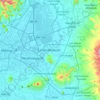
Name: Chimalhuacán topographic map, elevation, terrain.
Location: Chimalhuacán, 56351, Mexico (19.27393 -99.11801 19.59393 -98.79801)
Average elevation: 7,559 ft
Minimum elevation: 7,293 ft
Maximum elevation: 10,043 ft
Thank you for supporting this site ❤️
Make a donation
Make a donation
Gear up for your next adventure:
As an Amazon Associate, this site earns from qualifying purchases at no extra cost to you.