
Kovilanchery topographic map
Interactive map
Click on the map to display elevation.
About this map
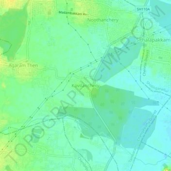
Name: Kovilanchery topographic map, elevation, terrain.
Average elevation: 36 ft
Minimum elevation: 10 ft
Maximum elevation: 75 ft
Other topographic maps
Click on a map to view its topography, its elevation and its terrain.
Tambaram
India > Tamil Nadu > Tambaram
Tambaram, Chengalpattu District, Tamil Nadu, 600045, India
Average elevation: 75 ft
Thirupur Kumaran Park
India > Tamil Nadu > Tambaram > Tambaram
Thirupur Kumaran Park, Selaiyur, Tambaram, Chengalpattu District, Tamil Nadu, 600073, India
Average elevation: 89 ft
Balaji Nagar
India > Tamil Nadu > Tambaram
Balaji Nagar, Tambaram, Chengalpattu District, Tamil Nadu, 600073, India
Average elevation: 72 ft
Noothanchery
India > Tamil Nadu > Tambaram > Noothanchery
Noothanchery, Tambaram, Chengalpattu District, Tamil Nadu, 600126, India
Average elevation: 39 ft