
Make a donation
Gear up for your next adventure:
As an Amazon Associate, this site earns from qualifying purchases at no extra cost to you.
Warren topographic map
Click on the map to display elevation.
Make a donation
Gear up for your next adventure:
As an Amazon Associate, this site earns from qualifying purchases at no extra cost to you.
About this map
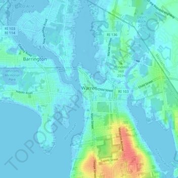
Name: Warren topographic map, elevation, terrain.
Location: Warren, Bristol County, Rhode Island, 02885, United States (41.69824 -71.29111 41.76162 -71.22546)
Average elevation: 20 ft
Minimum elevation: -23 ft
Maximum elevation: 154 ft
Bristol County trails, hiking, mountain biking, running and outdoor activities
Make a donation
Gear up for your next adventure:
As an Amazon Associate, this site earns from qualifying purchases at no extra cost to you.
Other topographic maps
Click on a map to view its topography, its elevation and its terrain.
Touisset Wildlife Refuge
United States > Rhode Island > Bristol County > Warren
Average elevation: 20 ft
Make a donation
Gear up for your next adventure:
As an Amazon Associate, this site earns from qualifying purchases at no extra cost to you.