
Cretas topographic map
Interactive map
Click on the map to display elevation.
About this map
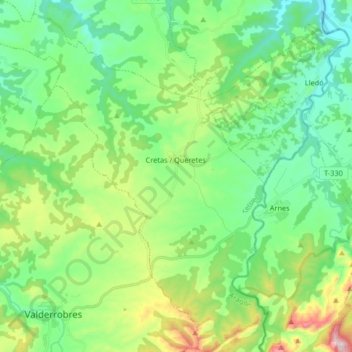
Name: Cretas topographic map, elevation, terrain.
Location: Cretas, Matarraña, Teruel, Aragón, España (40.85999 0.11593 40.98435 0.25559)
Average elevation: 1,749 ft
Minimum elevation: 1,214 ft
Maximum elevation: 3,136 ft
Other topographic maps
Click on a map to view its topography, its elevation and its terrain.
Estrechos del Parrizal
España > Aragón > Matarraña > Beceite
Estrechos del Parrizal, Beceite, Matarraña, Teruel, Aragón, 44588, España
Average elevation: 3,268 ft
La Fresneda
La Fresneda, Matarraña, Teruel, Aragón, 44596, España
Average elevation: 1,739 ft
La Portellada
La Portellada, Matarraña, Teruel, Aragón, 44589, España
Average elevation: 2,028 ft
Valderrobres
Valderrobres, Matarraña, Teruel, Aragón, 44580, España
Average elevation: 2,441 ft
Valdeltormo
Valdeltormo, Matarraña, Teruel, Aragón, 44620, España
Average elevation: 1,598 ft