
Hakahau topographic map
Interactive map
Click on the map to display elevation.
About this map
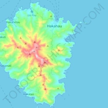
Name: Hakahau topographic map, elevation, terrain.
Average elevation: 400 ft
Minimum elevation: -10 ft
Maximum elevation: 3,015 ft
Other topographic maps
Click on a map to view its topography, its elevation and its terrain.
Hakahetau
France > Polynésie française > Îles Marquises > Ua Pou
Hakahetau, Ua Pou, Îles Marquises, Polynésie française, France
Average elevation: 371 ft