
Buttermere topographic map
Interactive map
Click on the map to display elevation.
About this map
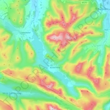
Name: Buttermere topographic map, elevation, terrain.
Location: Buttermere, Cumberland, Angleterre, Royaume-Uni (54.49658 -3.32039 54.61107 -3.19807)
Average elevation: 1,135 ft
Minimum elevation: 236 ft
Maximum elevation: 2,907 ft
Other topographic maps
Click on a map to view its topography, its elevation and its terrain.
Keswick
Royaume-Uni > Angleterre > Cumberland
Keswick, Cumberland, Angleterre, Royaume-Uni
Average elevation: 420 ft
Longtown
Royaume-Uni > Angleterre > Cumberland
Longtown, Cumberland, Angleterre, CA6 5UY, Royaume-Uni
Average elevation: 89 ft
Carlisle
Royaume-Uni > Angleterre > Cumberland
Carlisle, Cumberland, Angleterre, Royaume-Uni
Average elevation: 102 ft