
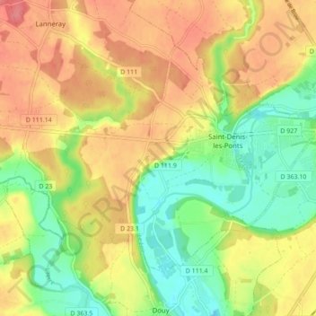
Saint-Denis-les-Ponts topographic map
Interactive map
Click on the map to display elevation.
About this map
Name: Saint-Denis-les-Ponts topographic map, elevation, terrain.
Average elevation: 433 ft
Minimum elevation: 318 ft
Maximum elevation: 535 ft
Other topographic maps
Click on a map to view its topography, its elevation and its terrain.
La Pinoterie
France > Centre-Val de Loire > Eure-et-Loir > Saint-Denis-Lanneray > La Pinoterie
La Pinoterie, Saint-Denis-les-Ponts, Saint-Denis-Lanneray, Châteaudun, Eure-et-Loir, Centre-Val de Loire, France métropolitaine, 28200, France
Average elevation: 430 ft
Vilquier
France > Centre-Val de Loire > Eure-et-Loir > Saint-Denis-Lanneray > Vilquier
Vilquier, Saint-Denis-les-Ponts, Saint-Denis-Lanneray, Châteaudun, Eure-et-Loir, Centre-Val de Loire, France métropolitaine, 28200, France
Average elevation: 449 ft