
Enclos des grues de Mandchourie topographic map
Interactive map
Click on the map to display elevation.
About this map
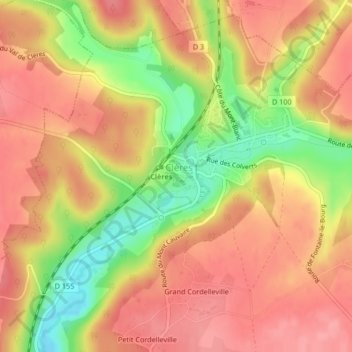
Name: Enclos des grues de Mandchourie topographic map, elevation, terrain.
Average elevation: 443 ft
Minimum elevation: 243 ft
Maximum elevation: 558 ft
Other topographic maps
Click on a map to view its topography, its elevation and its terrain.
Grand Cordelleville
France > Normandie > Seine-Maritime > Clères
Grand Cordelleville, Clères, Rouen, Seine-Maritime, Normandie, France métropolitaine, 76690, France
Average elevation: 469 ft