
Dubnica nad Váhom topographic map
Interactive map
Click on the map to display elevation.
About this map
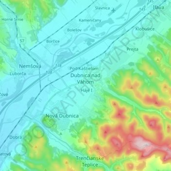
Name: Dubnica nad Váhom topographic map, elevation, terrain.
Average elevation: 1,014 ft
Minimum elevation: 705 ft
Maximum elevation: 2,297 ft
It is located on the Váh river, in the Ilava Basin, between the White Carpathians and Strážovské vrchy mountains, at an altitude of 242 metres. The town's cadastral area is composed of Dubnica and "city part" Prejta, annexed in 1973.