
Lac de Cottepens topographic map
Interactive map
Click on the map to display elevation.
About this map
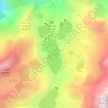
Name: Lac de Cottepens topographic map, elevation, terrain.
Average elevation: 7,470 ft
Minimum elevation: 5,476 ft
Maximum elevation: 9,154 ft
Other topographic maps
Click on a map to view its topography, its elevation and its terrain.
Rif Jany
France > Auvergne-Rhône-Alpes > Vaujany > Rif Jany
Rif Jany, Vaujany, Grenoble, Isère, Auvergne-Rhône-Alpes, France métropolitaine, 38114, France
Average elevation: 3,894 ft
Lac du Cos
France > Auvergne-Rhône-Alpes > Vaujany
Lac du Cos, La Ferrière, Vaujany, Grenoble, Isère, Auvergne-Rhône-Alpes, France métropolitaine, 38114, France
Average elevation: 7,661 ft
Lac Gris
France > Auvergne-Rhône-Alpes > Vaujany
Lac Gris, Crazy Mustang, Vaujany, Grenoble, Isère, Auvergne-Rhône-Alpes, France métropolitaine, 38114, France
Average elevation: 8,783 ft
Col du Rocher Blanc
France > Auvergne-Rhône-Alpes > Vaujany
Col du Rocher Blanc, Col Agnelin, La Ferrière, Vaujany, Grenoble, Isère, Auvergne-Rhône-Alpes, France métropolitaine, 38580, France
Average elevation: 8,176 ft
Glacier des Rousses
France > Auvergne-Rhône-Alpes > Vaujany
Glacier des Rousses, Crazy Mustang, Vaujany, Grenoble, Isère, Auvergne-Rhône-Alpes, France métropolitaine, 38114, France
Average elevation: 9,459 ft
Lac du Cos
France > Auvergne-Rhône-Alpes > Vaujany
Lac du Cos, Col Agnelin, La Ferrière, Vaujany, Grenoble, Isère, Auvergne-Rhône-Alpes, France métropolitaine, 38580, France
Average elevation: 7,661 ft