
Grotte de la Balme topographic map
Interactive map
Click on the map to display elevation.
About this map
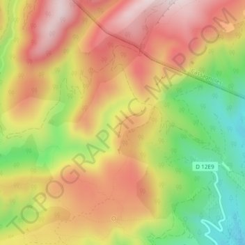
Name: Grotte de la Balme topographic map, elevation, terrain.
Average elevation: 1,677 ft
Minimum elevation: 863 ft
Maximum elevation: 2,339 ft
Other topographic maps
Click on a map to view its topography, its elevation and its terrain.
ventajou
France > Occitanie > Félines-Minervois
ventajou, d 12e9, L'Abeuradou, Félines-Minervois, Béziers, Hérault, Occitanie, France métropolitaine, 34210, France
Average elevation: 1,198 ft