
Frigento topographic map
Interactive map
Click on the map to display elevation.
About this map
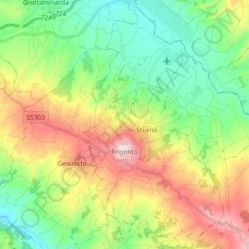
Name: Frigento topographic map, elevation, terrain.
Location: Frigento, Terre dell’Ufita, Avellino, Campania, Italy (40.97313 15.07812 41.07036 15.18522)
Average elevation: 1,762 ft
Minimum elevation: 1,053 ft
Maximum elevation: 2,982 ft
Other topographic maps
Click on a map to view its topography, its elevation and its terrain.
Quaglietta
Italy > Campania > Avellino > Calabritto
Quaglietta, Calabritto, Avellino, Campania, Italy
Average elevation: 1,050 ft
Monteverde
Monteverde, Avellino, Campania, Italy
Average elevation: 1,539 ft