
Mường Tè District topographic map
Interactive map
Click on the map to display elevation.
About this map
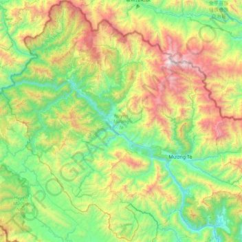
Name: Mường Tè District topographic map, elevation, terrain.
Location: Mường Tè District, Lai Châu Province, Vietnam (22.16697 102.32053 22.77992 102.98797)
Average elevation: 3,471 ft
Minimum elevation: 722 ft
Maximum elevation: 9,987 ft
Other topographic maps
Click on a map to view its topography, its elevation and its terrain.
Làng Giảng
Vietnam > Lai Chau province > Lai Châu
Làng Giảng, Sùng Phài Commune, Lai Châu, Lai Châu Province, Vietnam
Average elevation: 3,202 ft
Tam Đường District
Tam Đường District, Lai Chau province, Vietnam
Average elevation: 4,321 ft