
Zimatlán topographic map
Interactive map
Click on the map to display elevation.
About this map
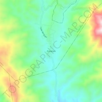
Name: Zimatlán topographic map, elevation, terrain.
Location: Zimatlán, Putla Villa de Guerrero, Oaxaca, México (16.91306 -97.85083 16.95306 -97.81083)
Average elevation: 3,041 ft
Minimum elevation: 2,474 ft
Maximum elevation: 4,222 ft
Other topographic maps
Click on a map to view its topography, its elevation and its terrain.
San Juan Lagunas
México > Oaxaca > Putla Villa de Guerrero
San Juan Lagunas, Putla Villa de Guerrero, Oaxaca, México
Average elevation: 2,448 ft
Putla Villa de Guerrero
México > Oaxaca > Putla Villa de Guerrero
Putla Villa de Guerrero, Oaxaca, México
Average elevation: 2,631 ft