
Beyşehir topographic map
Interactive map
Click on the map to display elevation.
About this map
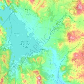
Name: Beyşehir topographic map, elevation, terrain.
Location: Beyşehir, Konya, Central Anatolia Region, Turkey (37.43107 31.27295 38.02078 31.98470)
Average elevation: 4,364 ft
Minimum elevation: 3,612 ft
Maximum elevation: 7,871 ft
Other topographic maps
Click on a map to view its topography, its elevation and its terrain.
Güneşevler Mahallesi
Turkey > Central Anatolia Region > Güneşevler Mahallesi
Güneşevler Mahallesi, Altındağ, Ankara, Central Anatolia Region, Turkey
Average elevation: 2,953 ft
Benzer
Turkey > Central Anatolia Region > Benzer
Benzer, Kaman, Kırşehir, Central Anatolia Region, Turkey
Average elevation: 3,356 ft
Basri
Turkey > Central Anatolia Region > Basri
Basri, Polatlı, Ankara, Central Anatolia Region, Turkey
Average elevation: 3,176 ft
Talas
Turkey > Central Anatolia Region
Talas, Kayseri, Central Anatolia Region, Turkey
Average elevation: 5,285 ft