
Ulhas River topographic map
Interactive map
Click on the map to display elevation.
About this map
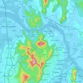
Name: Ulhas River topographic map, elevation, terrain.
Location: Ulhas River, Mira-Bhayander, Thane, Maharashtra, 401301, India (19.20006 72.82803 19.32627 73.02526)
Average elevation: 161 ft
Minimum elevation: -10 ft
Maximum elevation: 1,585 ft
Other topographic maps
Click on a map to view its topography, its elevation and its terrain.
Mira-Bhayander
India > Maharashtra > Mira-Bhayander
Mira-Bhayander, Thane, Maharashtra, 401101, India
Average elevation: 131 ft
Panju Island
India > Maharashtra > Mira-Bhayander
Panju Island, Mira-Bhayander, Thane, Maharashtra, 401105, India
Average elevation: 92 ft