
Einhausen topographic map
Interactive map
Click on the map to display elevation.
About this map
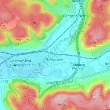
Name: Einhausen topographic map, elevation, terrain.
Average elevation: 1,243 ft
Minimum elevation: 961 ft
Maximum elevation: 1,670 ft
Other topographic maps
Click on a map to view its topography, its elevation and its terrain.
Petrus (12. Apostel)
Germany > Thuringia > Landkreis Schmalkalden-Meiningen > Steinbach-Hallenberg
Petrus (12. Apostel), Steinbach-Hallenberg, Landkreis Schmalkalden-Meiningen, Thuringia, Germany
Average elevation: 2,310 ft
Kaltensundheim
Germany > Thuringia > Landkreis Schmalkalden-Meiningen > Kaltennordheim
Kaltensundheim, Kaltennordheim, Hohe Rhön, Landkreis Schmalkalden-Meiningen, Thuringia, 36542, Germany
Average elevation: 1,683 ft
Kerbe
Germany > Thuringia > Landkreis Schmalkalden-Meiningen > Steinbach-Hallenberg > Viernau
Kerbe, Viernau, Steinbach-Hallenberg, Landkreis Schmalkalden-Meiningen, Thuringia, 98587, Germany
Average elevation: 1,467 ft
Oberhof
Germany > Thuringia > Landkreis Schmalkalden-Meiningen
Oberhof, Landkreis Schmalkalden-Meiningen, Thuringia, 98559, Germany
Average elevation: 2,457 ft