Geolocate

Froxán topographic map

Click on the map to display elevation.

About this map
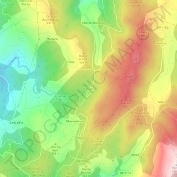
Name: Froxán topographic map, elevation, terrain.

Location: Froxán, Vilacova, Lousame, Noia, A Coruña, Galicia, 15212, Spain (42.73520 -8.83372 42.77520 -8.79372)

Average elevation: 1,093 ft

Minimum elevation: 272 ft

Maximum elevation: 2,018 ft

Other topographic maps

Click on a map to view its topography, its elevation and its terrain.
Lousame

Spain > Galicia > Noia

Average elevation: 840 ft

Gear up for your next adventure:

🪶Camp Gear Gift Set - Perfect gift bundle for outdoor fans
⌚GPS Sports Watch - GPS watch for running, hiking and training
🚁Photography Drones - Capture stunning aerial views of landforms and topography
🪶Multi‑Purpose Knife - Useful blade for camp and trail
🥩Freeze-Dried Meals - Nutritious and lightweight food for remote expeditions

As an Amazon Associate, this site earns from qualifying purchases at no extra cost to you.