
Thank you for supporting this site ❤️
Make a donation
Make a donation
Gear up for your next adventure:
As an Amazon Associate, this site earns from qualifying purchases at no extra cost to you.
Musselburgh topographic map
Click on the map to display elevation.
Thank you for supporting this site ❤️
Make a donation
Make a donation
Gear up for your next adventure:
As an Amazon Associate, this site earns from qualifying purchases at no extra cost to you.
About this map
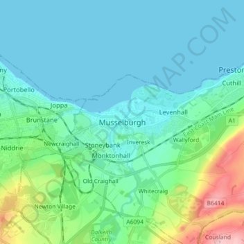
Name: Musselburgh topographic map, elevation, terrain.
Location: Musselburgh, East Lothian, Scotland, EH21 7DX, United Kingdom (55.90212 -3.09385 55.98212 -3.01385)
Average elevation: 105 ft
Minimum elevation: 0 ft
Maximum elevation: 564 ft
Thank you for supporting this site ❤️
Make a donation
Make a donation
Gear up for your next adventure:
As an Amazon Associate, this site earns from qualifying purchases at no extra cost to you.