
Thank you for supporting this site ❤️
Make a donation
Make a donation
Gear up for your next adventure:
As an Amazon Associate, this site earns from qualifying purchases at no extra cost to you.
Tosari topographic map
Click on the map to display elevation.
Thank you for supporting this site ❤️
Make a donation
Make a donation
Gear up for your next adventure:
As an Amazon Associate, this site earns from qualifying purchases at no extra cost to you.
About this map
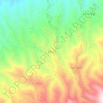
Name: Tosari topographic map, elevation, terrain.
Location: Tosari, Pasuruan, 67177, Indonesia (-7.90428 112.88055 -7.86428 112.92055)
Average elevation: 5,413 ft
Minimum elevation: 4,049 ft
Maximum elevation: 7,113 ft
Thank you for supporting this site ❤️
Make a donation
Make a donation
Gear up for your next adventure:
As an Amazon Associate, this site earns from qualifying purchases at no extra cost to you.