
Eprapah Creek topographic map
Interactive map
Click on the map to display elevation.
About this map
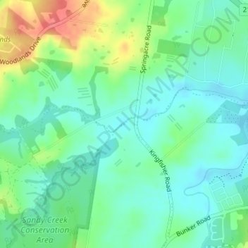
Name: Eprapah Creek topographic map, elevation, terrain.
Location: Eprapah Creek, Brisbane, Queensland, 4164, Australia (-27.58805 153.25284 -27.58662 153.25542)
Average elevation: 105 ft
Minimum elevation: 39 ft
Maximum elevation: 253 ft
Other topographic maps
Click on a map to view its topography, its elevation and its terrain.
Brisbane
Australia > Queensland > Brisbane
Brisbane, Queensland, 4000, Australia
Average elevation: 148 ft
Wilston
Australia > Queensland > Brisbane
Wilston, Brisbane, Queensland, 4051, Australia
Average elevation: 85 ft
Blue Lake section of Naree Budjong Djara NP
Australia > Queensland > Brisbane
Blue Lake section of Naree Budjong Djara NP, Blue Lake Walk, Brisbane, Queensland, Australia
Average elevation: 240 ft
Kedron Brook
Australia > Queensland > Brisbane
Kedron Brook, Brisbane, Queensland, 4051, Australia
Average elevation: 128 ft