
Make a donation
Gear up for your next adventure:
As an Amazon Associate, this site earns from qualifying purchases at no extra cost to you.
Künzelsau topographic map
Click on the map to display elevation.
Make a donation
Gear up for your next adventure:
As an Amazon Associate, this site earns from qualifying purchases at no extra cost to you.
Künzelsau
The city of Künzelsau is located, at elevation 210–435 m (689–1,427 ft), along the Kocher River, a right tributary of the Neckar River, some 40 km east (25 mi) of Heilbronn. The city is, after Öhringen, the second largest city of the Hohenlohe district, whose seat it is.
Make a donation
Gear up for your next adventure:
As an Amazon Associate, this site earns from qualifying purchases at no extra cost to you.
About this map
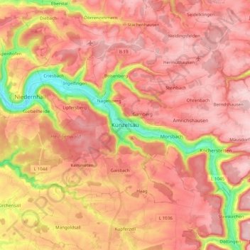
Name: Künzelsau topographic map, elevation, terrain.
Average elevation: 1,181 ft
Minimum elevation: 650 ft
Maximum elevation: 1,463 ft
Make a donation
Gear up for your next adventure:
As an Amazon Associate, this site earns from qualifying purchases at no extra cost to you.
Other topographic maps
Click on a map to view its topography, its elevation and its terrain.